By Paul Caffyn
–
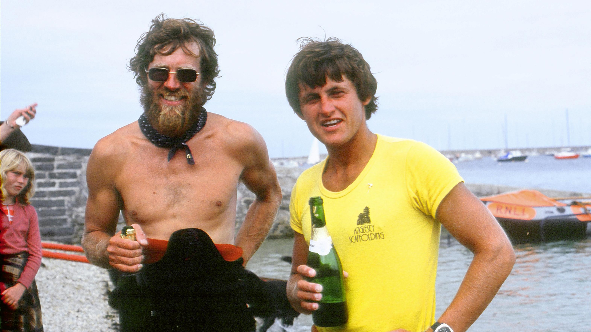
A summary taken from Paul Caffyn’s records showing the paddling legs and daily distances of the first UK Circumnavigation in 1980. PSK
5 May – 28 July 1980 85 days 2,305 miles
Paddlers: Paul Caffyn (NZ) and Nigel Dennis (GB)
Support Crew: Lesley Hadley (NZ)
Kayaks: HM model Nordkapps (extended keel stern)
r/d = rest day
w/b = weatherbound day
| Day | Date | From – To | Mileage | Cum. Tally | |
| 1 | 05-May | Holyhead – Church Bay – Cemlyn Bay (Anglesey) | 12 | 12 | |
| 2 | 06-May | Cemlyn Bay – Bull Bay (Anglesey) | 7 | 19 | |
| 3 | 07-May | Bull Bay – Penmon – Colwyn Bay – Rhyl Beach (Wales) | 36 | 55 | |
| 4 | 08-May | Rhyl Beach – Point of Ayr – Wallasey – Formby CG station | 31 | 86 | |
| 5 | 09-May | Formby CG Station – Blackpool – Rossall Point – Barrow on Furness | 43 | 129 | |
| 6 | 10-May | Barrow on Furnes – Bootle CG Station – Seascale – Whitehaven | 37 | 166 | |
| 7 | 11-May | Rest Day | 0 | 166 | r/d 1 |
| 8 | 12-May | Whitehaven – Mullock Bay – Isle of Whithorn (Scotland) | 39 | 205 | |
| 9 | 13-May | Isle of Whithorn – Monreith Bay – Port Logan | 35 | 240 | |
| 10 | 14-May | Port Logan – Port Patrick – Ballantrae | 33 | 273 | |
| 11 | 15-May | Ballantrae – Ailsa Crag – South End, Carskey Bay | 39 | 312 | |
| 12 | 16-May | Southend, Carskey Bay – Macrahanish – Mousdale – Ronachan Bay | 40 | 352 | |
| 13 | 17-May | Ronachan Bay – Carsaig Bay – Asknish Bay | 39 | 391 | |
| 14 | 18-May | Asknish Bay – Oban – Kilchoan | 48 | 439 | |
| 15 | 19-May | Kilchoan – Fascadale Bay – Glenacross | 32 | 471 | |
| 16 | 20-May | Glenacross – Kyle of Lochalsh – Camusteel | 38 | 509 | |
| 17 | 21-May | Camusteel – Applecross | 2 | 511 | |
| 18 | 22-May | Applecross – Red Point | 17 | 528 | |
| 19 | 23-May | Red Point – Big Sand | 7 | 535 | |
| 20 | 24-May | Big Sand – Opinian – Reiff | 33 | 568 | |
| 21 | 25-May | Reiff – Cluas Deas – Scourie | 26 | 594 | |
| 22 | 26-May | Scourie – Kinlochbervie – Cape Wrath – Durness | 39 | 633 | |
| 23 | 27-May | Weather Bound day | 0 | 633 | w/b 1 |
| 24 | 28-May | Durness – Talmine – Tubeg (Skerray Bay) | 20 | 653 | |
| 25 | 29-May | Skerray Bay (Tubeg) – Melvich Bay (Portskerra) – Scrabster | 32 | 685 | |
| 26 | 30-May | Scrabster – Duncansby Head – Keiss – Wick | 39 | 724 | |
| 27 | 31-May | Wick – Lybster Bay – Helmsdale | 34 | 758 | |
| 28 | 01-Jun | Helmsdale – Brora – Tarbet Ness – Newtown | 38 | 796 | |
| 29 | 02-Jun | Newtown – Spey Bay – Sandend Bay | 29 | 825 | |
| 30 | 03-Jun | Sandend Bay – Banff – Pennan – Rattray – Peterhead | 48 | 873 | |
| 31 | 04-Jun | Peterhead | 0 | 873 | w/b 2 |
| 32 | 05-Jun | Peterhead – Collieston – Aberdeen- Cowie (near Stonehaven) | 42 | 915 | |
| 33 | 06-Jun | Cowie (near Stonehaven) – Bervie Bay – Fishtown of Usan – Arbroath | 34 | 949 | |
| 34 | 07-Jun | Arbroath | 0 | 949 | w/b 3 |
| 35 | 08-Jun | Arbroath – Fife Ness – North Berwick | 35 | 984 | |
| 36 | 09-Jun | North Berwick,Dunbar – CG Stn – St Abb’s – Marshall Meadows | 37 | 1021 | |
| 37 | 10-Jun | Marshall Meadows – Bamburgh – Craster – Amble | 42 | 1063 | |
| 38 | 11-Jun | Amble | 0 | 1063 | w/b 4 |
| 39 | 12-Jun | Amble | 0 | 1063 | w/b 5 |
| 40 | 13-Jun | Amble – Newbiggin Bay – Tynemouth | 27 | 1090 | |
| 41 | 14-Jun | Tynemouth | 0 | 1090 | w/b6 |
| 42 | 15-Jun | Tynemouth | 0 | 1090 | w/b 7 |
| 43 | 16-Jun | Tynemouth – Dene Mouth – Tees Mouth | 31 | 1121 | |
| 44 | 17-Jun | Tees Mouth – Staithes – Whitby – Cayton Bay | 40 | 1161 | |
| 45 | 18-Jun | Cayton Bay – Flamborough Head -Bridlington – Tunstall | 45 | 1206 | |
| 46 | 19-Jun | Tunstall – Easington – Spurn Head | 19 | 1225 | |
| 47 | 20-Jun | Spurn Head | 0 | 1225 | w/b 8 |
| 48 | 21-Jun | Spurn Head – weather | 0 | 1225 | w/b 9 |
| 49 | 22-Jun | Spurn Head – Mablethorpe – Skegness | 32 | 1257 | |
| 50 | 23-Jun | Skegness – Scolt Point – Clay on Sea – Cromer | 46 | 1303 | |
| 51 | 24-Jun | Cromer – Happisburgh | 41 | 1344 | |
| 52 | 25-Jun | Happisburgh – Dunwich – Thorpeness | 23 | 1367 | |
| 53 | 26-Jun | Thorpeness – Felixstowe – Clacton-on-Sea | 36 | 1403 | |
| 54 | 27-Jun | Clacton-on-Sea | 0 | 1403 | w/b 10 |
| 55 | 28-Jun | Clacton-on-Sea | 0 | 1403 | w/b 11 |
| 56 | 29-Jun | Clacton-on-Sea – Reculver – Margate | 37 | 1440 | |
| 57 | 30-Jun | Margate – Deal – Dover | 26 | 1466 | |
| 58 | 01-Jul | Dover – Folkestone – Hythe | 13 | 1479 | |
| 59 | 02-Jul | Hythe – Dungeness – Cliff End – Langney Point (Eastbourne) | 44 | 1523 | |
| 60 | 03-Jul | Langney Point (Eastbourne) – Seaford – Brighton – Shoreham | 29 | 1552 | |
| 61 | 04-Jul | Shoreham – Worthing | 5 | 1557 | |
| 62 | 05-Jul | Worthing – Bognor Regis – East Wittering – Portsmouth | 35 | 1592 | |
| 63 | 06-Jul | Rest day at Portsmouth | 0 | 1592 | r/d 2 |
| 64 | 07-Jul | Portsmouth – Milford on Sea – Southbourne – Swanage | 46 | 1638 | |
| 65 | 08-Jul | Swanage – Kummeridge Bay – Ringstead Bay – Chesil Beach | 34 | 1672 | |
| 66 | 09-Jul | Chesil Beach – West Bay – Lyme Regis – Beer | 33 | 1705 | |
| 67 | 10-Jul | Beer – Budleigh-Salterton – Teignmouth – St Mary’s Bay – Beesands | 45 | 1750 | |
| 68 | 11-Jul | Beesands – Hope Cove – Rame Head | 33 | 1783 | |
| 69 | 12-Jul | Rame Head | 0 | 1783 | w/b 12 |
| 70 | 13-Jul | Rame Head – West Looe – Talland Bay | 46 | 1829 | |
| 71 | 14-Jul | Talland Bay> Fowey Hbr> Swanpool Bch>Falmouth – Kennack Sands | 45 | 1874 | |
| 72 | 15-Jul | Kennack Sands – Mousehole – Sennen Cove – sth. of St. Ives | 50 | 1924 | |
| 73 | 16-Jul | Near St.Ives – Portreath – Fistral Beach – Harlyn Bay | 39 | 1963 | |
| 74 | 17-Jul | Harlyn Bay – Port Isaac – Boscastle Harbour | 18 | 1981 | |
| 75 | 18-Jul | Boscastle Harbour | 0 | 1981 | w/b 13 |
| 76 | 19-Jul | Boscastle Harbour | 0 | 1981 | w/b 14 |
| 77 | 20-Jul | Boscastle Harbour | 0 | 1981 | w/b 15 |
| 78 | 21-Jul | Boscastle – Hartland Point – Clovelly – Ilfracombe | 53 | 2034 | |
| 79 | 22-Jul | Ilfracombe – Worms Head – Tenby | 46 | 2080 | |
| 80 | 23-Jul | Tenby – Broad Haven – Freshwater West Bay | 23 | 2103 | |
| 81 | 24-Jul | Freshwater West Bay – The Anvil – St Justinian – Bryhenllan | 44 | 2147 | |
| 82 | 25-Jul | Bryhenllan – Aberporth – New Quay | 30 | 2177 | |
| 83 | 26-Jul | New Quay – Aberystwyth – Tywyn – Abersoch | 57 | 2234 | |
| 84 | 27-Jul | Abersoch – Penrhyn Colmon – Trevor – Trearddur Bay | 59 | 2293 | |
| 85 | 28-Jul | Trearddur Bay – Holyhead | 12 | 2305 |
85 days start to finish
15 weatherbound & 2 rest days = 17
68 paddling days
all up average = 27.1 mpd
paddling day average = 33.9 mpd
[rl_gallery id=”510″]
Thankyou to Paul Caffyn for kindly providing access to his records. PSK 2016